2.0 km from the ship as the crow flies (0.2 km by the guide). The violet pin is the place, the blue one the cruise berth at Sydney.
The Rocks
Old sandstone streets and weekend markets beside the terminal.
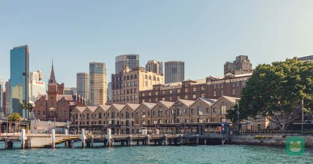
Photo: Dietmar Rabich — CC BY-SA 4.0 · License
What to expect
- Distance from port
- 0.2 km
- Approximate straight-line distance from Overseas Passenger Terminal to the mapped The Rocks, New South Wales reference point. This uses the Circular Quay terminal, not White Bay Cruise Terminal. Bondi is the coastal-walk start; the Manly activity uses the Circular Quay departure wharf, and the bridge point is a landmark reference rather than the BridgeClimb check-in. Boat travel and walking circuits are additional. This is not walking or driving distance, a complete tour route, or a transfer-time estimate. Check your actual berth and entrance before planning transport.
- Cost
- Free
- Exploring the public streets and browsing the markets is free. Meals, shopping, museums, tours and special events may cost extra.
- Tourist-trap risk
- Mixed
- Editorial assessment: a historic district beside the cruise terminal with a substantial dining and souvenir trade. Enjoy the lanes and architecture independently and compare optional purchases.
- Physical effort
- Moderate
- The neighborhood includes sloping streets, narrow lanes and historic paving; a short waterfront circuit is easier than exploring every uphill lane.
- Accessibility
- Partly accessible
- Historic cobblestone lanes, slopes and individual heritage-building thresholds create a mixed route. Plan a step-free street circuit and confirm any indoor venue’s entrance and toilets separately.
Sources and review
Checked 2026-10-26
Distance is approximate and measured from the cruise port, not the airport. Cost and tourist-trap risk are editorial assessments. Accessibility depends on the route, transport and facilities described in the notes. Not assessed means details have not yet been verified.
Quick answers
How far is The Rocks from the Sydney cruise port?
About 0.2 km from the cruise port. Approximate straight-line distance from Overseas Passenger Terminal to the mapped The Rocks, New South Wales reference point. This uses the Circular Quay terminal, not White Bay Cruise Terminal. Bondi is the coastal-walk start; the Manly activity uses the Circular Quay departure wharf, and the bridge point is a landmark reference rather than the BridgeClimb check-in. Boat travel and walking circuits are additional. This is not walking or driving distance, a complete tour route, or a transfer-time estimate. Check your actual berth and entrance before planning transport.
How much does The Rocks cost?
It is free, in Cruises Frog's assessment. Exploring the public streets and browsing the markets is free. Meals, shopping, museums, tours and special events may cost extra.
Is The Rocks a tourist trap?
It can be: the risk is mixed, in Cruises Frog's assessment. Editorial assessment: a historic district beside the cruise terminal with a substantial dining and souvenir trade. Enjoy the lanes and architecture independently and compare optional purchases.
Is The Rocks accessible?
Partly. Historic cobblestone lanes, slopes and individual heritage-building thresholds create a mixed route. Plan a step-free street circuit and confirm any indoor venue’s entrance and toilets separately.
Traveller reviews
What people who've been say. One review each; you can update yours.