17 km from the ship as the crow flies (16.8 km by the guide). The violet pin is the place, the blue one the cruise berth at Bridgetown.
The east coast at Bathsheba
Wild Atlantic surf and rock formations.
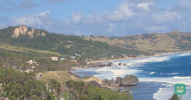
Photo: Postdlf — CC BY-SA 3.0 · License
What to expect
- Distance from port
- 16.8 km
- Approximate straight-line distance from Port of Bridgetown to the mapped Bathsheba, Barbados reference point. The origin is a harbor reference rather than your gangway. The historic-area distance uses one mapped reference, and the Mount Gay distance uses its Bridgetown Visitor Centre, not the St Lucy production distillery. This is not walking or driving distance, a complete tour route, or a transfer-time estimate. Check your actual berth and entrance before planning transport.
- Cost
- Free
- Viewing the public coastline is free; budget separately for a cross-island taxi, guided tour, food or surf activity. Confirm the return fare or pickup before leaving the port.
- Tourist-trap risk
- Low
- Editorial assessment: a dramatic coastal landscape and surf village. Its value is the scenery; it is best planned as a viewpoint outing rather than assuming a calm-water swimming beach.
- Physical effort
- Moderate
- A vehicle-based viewpoint stop is gentle, while beach sand, rocks and longer coastal walks add effort. Avoid scrambling onto wet rock formations.
- Accessibility
- Partly accessible
- A roadside scenic stop is different from reaching the sand or tidal rocks. A complete accessible route and adapted facilities were not verified for the whole village; arrange a suitable vehicle and specific viewpoint with the driver.
Sources and review
Checked 2026-10-26
Distance is approximate and measured from the cruise port, not the airport. Cost and tourist-trap risk are editorial assessments. Accessibility depends on the route, transport and facilities described in the notes. Not assessed means details have not yet been verified.
Quick answers
How far is The east coast at Bathsheba from the Bridgetown cruise port?
About 16.8 km from the cruise port. Approximate straight-line distance from Port of Bridgetown to the mapped Bathsheba, Barbados reference point. The origin is a harbor reference rather than your gangway. The historic-area distance uses one mapped reference, and the Mount Gay distance uses its Bridgetown Visitor Centre, not the St Lucy production distillery. This is not walking or driving distance, a complete tour route, or a transfer-time estimate. Check your actual berth and entrance before planning transport.
How much does The east coast at Bathsheba cost?
It is free, in Cruises Frog's assessment. Viewing the public coastline is free; budget separately for a cross-island taxi, guided tour, food or surf activity. Confirm the return fare or pickup before leaving the port.
Is The east coast at Bathsheba a tourist trap?
No: the risk is low, in Cruises Frog's assessment. Editorial assessment: a dramatic coastal landscape and surf village. Its value is the scenery; it is best planned as a viewpoint outing rather than assuming a calm-water swimming beach.
Is The east coast at Bathsheba accessible?
Partly. A roadside scenic stop is different from reaching the sand or tidal rocks. A complete accessible route and adapted facilities were not verified for the whole village; arrange a suitable vehicle and specific viewpoint with the driver.
Traveller reviews
What people who've been say. One review each; you can update yours.